Leading with Landscapes: Landscape architects bring delight to large urban infrastructure projects
TEXT BY NETAMI STUART AND PINA MALLOZZI
Landscape architecture is a multidisciplinary field, requiring knowledge in design, horticulture, dendrology, geomorphology, architecture and ecology–to name a few. Because their formal training teaches landscape architects to be generalists, across a wide spectrum of disciplines, they can tackle projects at varying scales and levels of complexity. As a result, landscape architects bring a unique perspective to infrastructure design, and make great project leaders.
Perhaps the most famous example of this leadership is New York’s Central Park, famously designed by Frederick Law Olmsted. Olmsted, regarded as a pioneer in the field, did not shy away from complexity. After winning a design competition for Central Park in 1858, Olmsted, together with landscape architect Calvert Vaux, transformed approximately 300 hectares in the downtown of a quickly expanding metropolis into its most cherished asset. The most visited park in the world, Central Park has served as a model for urban greenspace and, more generally, for how landscape architecture can be a catalyst for city building. In Boston, Olmsted’s plan to create a connective park system (known as the Emerald Necklace), while re-routing sewage and cleaning up polluted marshland, illustrates how integrating infrastructure as a landscape into the city seamlessly can shape how people experience public space. It shows us how transformative landscape architecture can be. There continues to be much to learn from the leadership Olmsted and others brought to their craft and the value they placed on shaping spaces for human experience, regardless of the inherent function.
Leading with Landscape has been one of the principles of Waterfront Toronto for over 15 years, guiding the tripartite government agency to commission landscape architects to lead the design of some of its most ambitious and innovative infrastructure projects. Here are three case studies where landscape architects have been retained by Waterfront Toronto as the prime consultant of large multidisciplinary design teams, and landscape truly leads.
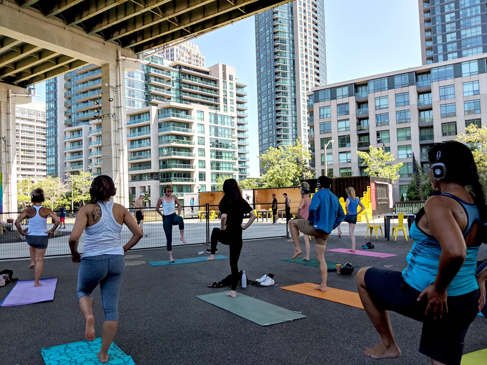
The Bentway
The Bentway is a unique public space that transforms 1.75 kilometres underneath Toronto’s Gardiner Expressway into a new gathering place for our city’s growing population. The initial phase, designed by landscape architects at Public Work together with Ken Greenberg—from Strachan Avenue to Bathurst Street—knits together seven local neighbourhoods, with over 70,000 residents, while providing access to important attractions and destinations.
The Bentway is a member of the High Line Network, an international group of likeminded projects turning underutilized ifrastructure into public space—inspired by the transformation of the West Side Elevated Line in New York City, railway infrastructure designed to take freight trains off of busy roadways, turned into a 2.3-kilometre long greenway with both ecological and cultural richness, visited by 7.6 million people in 2015.
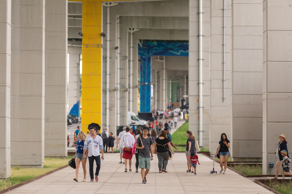
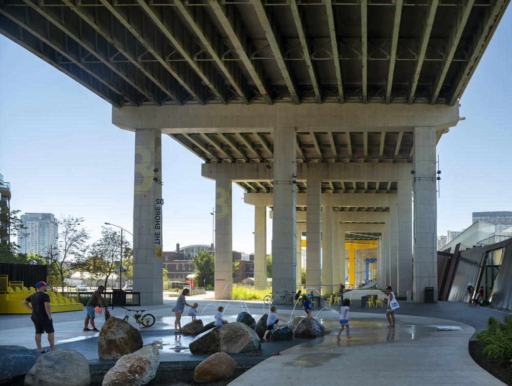
Projects like the Bentway and the High Line show landscape architects have the unique ability to see industrial relics as more than infrastructure built to move more people and goods through our cities. Their interdisciplinary approach lets them use their imagination to uncover the beauty of these spaces: the juxtaposition of landscape ecology with the massive scale and utilitarian design of infrastructure creates opportunities for unique experiences, which the landscape architect is able to curate. The Bentway, once a dirt patch spotted with spalling concrete “bents” from the highway above, is now home to a liquid landscape, an events dock, an ice skating trail and a splash zone: all beneath the cathedral-like space created by the highway. This simple landscape creates a canvas for cultural and arts programming and provides much needed public space in a growing city.
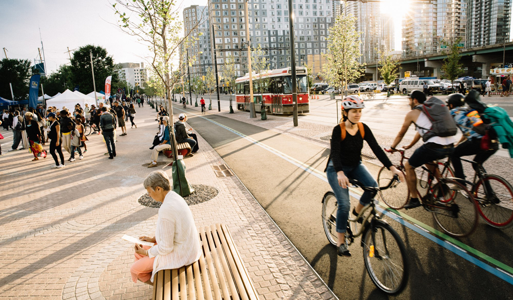
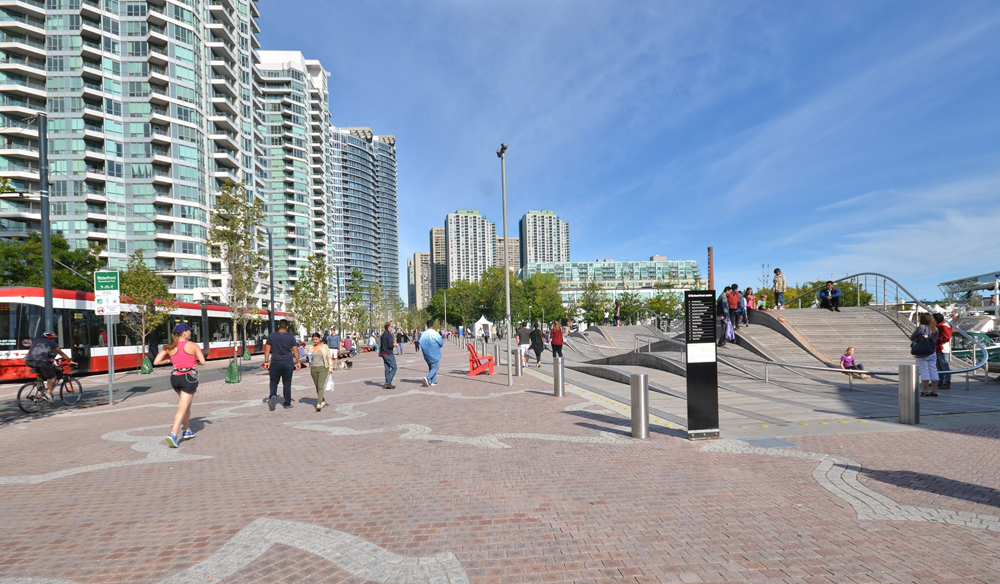
Queens Quay Boulevard
Queens Quay, which runs east-west parallel to the lakefront, is the waterfront’s main street. It spans more than three kilometres from Bathurst Street to Parliament Street in the central waterfront. It has been transformed into one of the world’s first complete streets.
Plans for Queens Quay were developed after an international design competition which selected a team led by West 8 and DTAH, landscape architects. The brief: ensure the central waterfront becomes a destination and not just the uninviting traffic corridor it has historically been. Now, this world-class street links major destinations along the water’s edge, creates pedestrian- and cycling-friendly promenades, and encourages an economically vibrant area that serves as a destination for locals and visitors alike. This once-auto focused environment with little space for pedestrians and no dedicated space for cyclists now provides a generous public promenade along the shores of Lake Ontario, a dedicated bi-directional cycling path, and high order light rail transit, all while maintaining auto access to properties along its length and connections north to the broader road network.
While largely a transit and transportation project, the landscape architects led the design team with a strong vision for the street—this acted throughout the design process as the mediator for complex technical issues. The public realm vision, simple in nature, guided decision-making related to utility design, signalization, grading, stormwater management, structural design, soil specifications, irrigation, and lighting. The result is that the sum of the parts is greater than each of the individual pieces. The landscape was not treated as a value-add sprinkled near the end of the design process, but rather was the core reason for doing the project.
Port Lands Flood Protection
Looking to the future, the Port Lands Flood Protection project is a 41-hectare infrastructure project which will naturalize and extend the mouth of the Lower Don River into Toronto’s Port Lands. Once complete, this $1.25-billion project will unlock nearly 290 hectares (715 acres) of land currently within the flood plain for future city growth. This project will have a significant influence on the City of Toronto, both in terms of creating crucial infrastructure, and as a catalyst for visionary city building.
In addition to providing much needed flood protection, it will create 37 hectares of new publicly accessible greenspace, including a network of new public parks along the banks of the new river, and a series of connected aquatic, wetland, and terrestrial habitats. The route of the river will carve a new island—Villiers Island—that will evolve into a highly sustainable mixed-use community with four distinct water’s edges.
The Port Lands Flood Protection project is being designed by a team led by Michael Van Valkenburgh and Associates which consists of hundreds of people from various disciplines, ranging from water resources, structural, ecological, civil and marine engineering to wayfinding, play, and lighting design. Each team member plays a specific and important role. This team is being led by a landscape architecture firm with an inspiring vision that drives the whole team towards excellence. As generalists, the project leads landscape architects are able to understand and decode the complexity of this multi-disciplinary challenge. Success for a project like this will be characterized by the creation of a seamless experience, through a series of unique ecosystems and highly engineered landscape typologies. Once the project is established, the line between the flood plain and the parks should be invisible to visitors, and the heavily-designed infrastructure built to protect hundreds of hectares from flooding should be almost indiscernible from the public space.
In each of these projects, the landscape architect had a strong and holistic vision; the technical capacity to lead the complex process of city building; and the ability to guide decision-making throughout design and construction. These capacities allowed the leads to deliver major projects that were not just traditional parks, but also streetscapes, infrastructure and urban renewal projects.
However, it is the landscape architect’s aspiration to create delight within our cities that truly separates them from their peers. The first principle articulated in the New York City High Performance Landscape Guidelines is to “Engage users: create delight, in any of its forms— seasonal beauty, discovery, aesthetic beauty, and even whimsy.”
In fast-growing cities where parks and public space are becoming an increasingly limited resource, each open space needs to work hard. Often, opportunities to create delightful experiences in the public realm are not obvious—it takes a project lead who 11 can see how landscape can be integrated with necessary infrastructure (like roads, highways, rail or flood measures). As lead on these projects, the landscape architect’s gift is to consider how people will inhabit and enjoy a place, and to ensure that each precious new public space will be the place of endless delightful experiences.
BIOS/ NETAMI STUART, OALA, HAS BEEN WORKING TO REVITALIZE PARKS IN TORONTO FOR 15 YEARS. SHE IS THE SENIOR PROJECT MANAGER AT WATERFRONT TORONTO.
PINA MALLOZZI, BLA, MLA, IS VICE PRESIDENT, DESIGN AT WATERFRONT TORONTO, AND AN ADVOCATE FOR USER EXPERIENCE IN THE DESIGN OF PUBLIC INFRASTRUCTURE.